


A month in Sedona
Condensing a month of adventures into one post at a time is... mmm... but the intent here to create a repository of my recommendations and routes I did in Sedona from Dec 28 - Jan 31 as I work remotely in 2021.
Sedona Overall
- Sedona is in Northern Arizona, close to the Grand Canyon, at approximately 4500 ft, so you're at elevation and things like brownies bake strangely. The weather in January was below freezing at night and sunny 50-70F during the day (so... perfect...). The mornings are very cold, so best to plan things in the afternoon. Sedona is also in a pseudo valley between multiple mountain ranges, so the weather dramatically changes (re: colder, snowier) 30 minutes away.
- Mountain Biking. I found the translation in trails to be +1.5 in hardness from Michigan. I can usually do Intermediate (Blue) trails in Michigan on my Thunderhawk (rigid, 2.25" tires) but I was pretty terrified/walking on anything other than Easy (Green) Trails in Sedona. Lime Kiln and Hiline were very memorable for me, but more in a "I peed myself multiple times" ways.
- There are trails (hiking/biking) everywhere - every neighborhood and in all directions. People asked me "where should I stay if I want to be near the trails". Anywhere. Literally anywhere in Sedona and you're good.
- There's free camping in the National Forest Land (so off the dirt roads). A lot of people #vanlifing in Sedona.
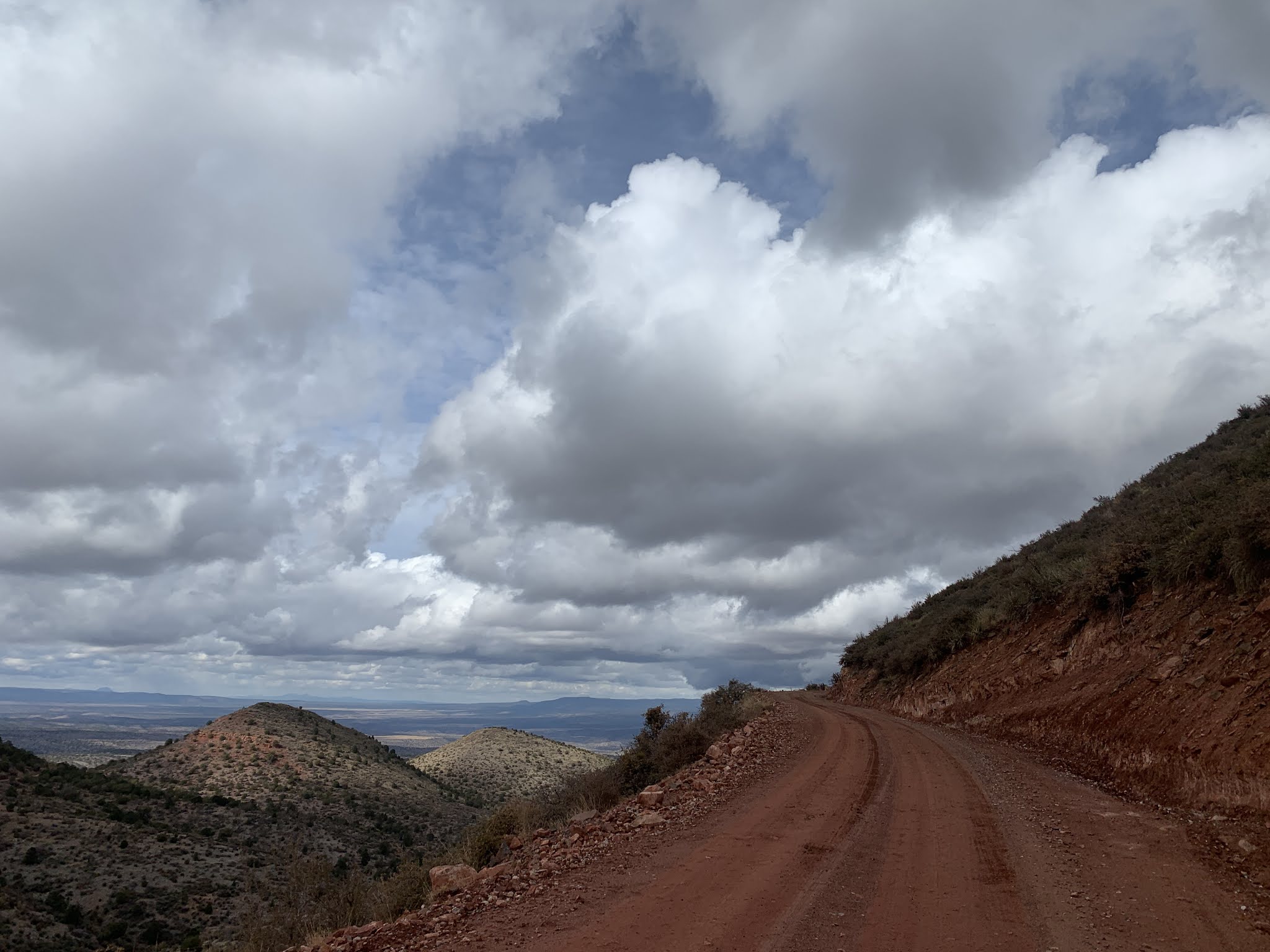
- The road/gravel options are perfect but limited
Sedona
 |
| Schnelbe Tooth Breaker |
What a great introduction for me to re-learn what a "road" means in Sedona. Again, ATV trails in Sedona are semi-unrideable by bikes and the "dirt roads" are ... omfg. Schnelbe hill road is listed as a connecting road on googlemaps between Sedona and I-17 -- it looks super innocuous, a ~2300 ft climb over 12 miles. I recommend a Full-Suspension Mountain, a Hardtail if you're feeling cocky, and a gravel bike if you have great life insurance.
I tried to make a loop out of this; was not remotely successful. Do this as an out and back and be careful about the temperature change... it was 70F and I was HOT at the bottom, on the top it was low 40s and snow/ice.
 |
| The Best of Sedona Gravel |
I don't like doing multiple iterations of the same route, but I really wanted to have one classic gravel route that I could default to/recommend. So after a few iterations, this is my masterpiece. Caveats: it's a lot harder than it looks, you will hit a lot of sand, Cottonwood isn't super bike friendly, there's a stop for water at a graveyard, lots of washboard, and you'll be soooo glad to see pavement by the end. It's a beautiful route though; be careful on a hot day though!
My Workday Road Loop
Why mess with perfection? I found this out-n-back + loop pavement combination early in my explorations and it became my go-to "go outside and ride bike during lunch break" work day ride. You get a good bit of climbing, red rock loop is astounding and has minimal traffic/great shoulders, and the out-n-back will give you enough breath taking views to convince you that Sedona was an awesome place to visit/live <3
Why mess with perfection? I found this out-n-back + loop pavement combination early in my explorations and it became my go-to "go outside and ride bike during lunch break" work day ride. You get a good bit of climbing, red rock loop is astounding and has minimal traffic/great shoulders, and the out-n-back will give you enough breath taking views to convince you that Sedona was an awesome place to visit/live <3
 |
| Claire and I on the Workday Road Loop |
This loop is pretty fantastic - I recommend doing it "all right turns" heading towards 179 from Sedona towards Beaverhead Flats. There is a decent shoulder or low traffic for 90% of the route. Add in the red rock loop for a few bonus miles (7-8).
 |
| Beaverhead Flats road |
Prescott National Forest & Jerome
 |
| Ridge descent to Cherry - this was quite nasty |
The initial descent off the South Side of the ridge (first 1500 ft) was beautiful but terrifying. The sun was starting to set for me at this point, and the huge crevasses, rocks, and steep drops after sudden turns was the worst emotional rollercoaster I've ever been on. There's an out n back I did when I encountered private property with multiple signs (damn!).
Then, I made it to Cherry, and this was the best -- this was some of the best gravel riding in all of the Sedona area. It's a ~2500 ft (?) descent in a valley on mostly smooth, fast but curvy and fanscinating gravel down to Camp Verde. Then there was 20 miles of awful highway riding back to Cottonwood. The lesson you should take from this is either start in Camp Verde and go up (and then back) or bravely connect this section to the nice loop at the top (but do not do the front ridge, really, it's not badass, it's just a hike with your bike).
 |
| Part of weather challenges |
 |
| Beautiful Red Roads outside Jerome |
Weather did not cooperate with my plans this weekend, but there is some outstanding gravel riding outside Jerome (in fact, I saw other cyclists on this route!). This route was short (~35 miles), beautiful, and a great way to get some climbing and stellar views in. Perkinsville has a ton of gravel loop options and could be a great place to start.
Flagstaff Area
 |
| Views like this all around Mormon Lake |
Wait, why 2 routes? When I started at Stoneman Lake, it became very apparent to me within a few miles that I would not be able to do the Planned Route this time of year -- a 4 inch layer of ice and snow made the gravel/mud a slippery bike-hike (only fell twice, fortunately). I think this route would be fantastic in summer though - the forest was interesting and shaded, which would be perfect on a hot summer day.
The "unplanned" backup plan route was a pleasant surprise though! Mormon Lake (upper loop) is a roadie's dream - nice shoulder for biking and beautiful pavement around a mostly dried up lake. The gravel back from 3 to Stoneman Lake was much easier than the outbound route I took too.
 |
| Soft soil but a nice break from the car |
This was just a quick stop I did on the way home from Grand Canyon. It was a really nice break from driving, and I parked at the Red Mountain trailhead (a short 2 mile hike?). The loop was rougher terrain (gravel+ bikes recommended) and there's the option to extend it into a longer loop back there if you have time.
 |
| An easy and delightful day at Sunset Crater |
I messed this one up massively - I should have brought my "road" bike (35 mm gravel tires) and gone from Sunset Crater to Wupatki Monument and back. I didn't have the time (or energy, it was after the Prescott Forest death ride), so I only did a partial out and back. The pavement is perfection and the scenery ranges from forest, to Arizona desert, to lava fields, to mountains, etc. The traffic was super low on MLK day when I did it, but I can see this being quite crowded in the summer.
1 Comments